ROUTE 4:
From Arinaga Lighthouse to Agaete and Sardina Lighthouse
Day 1: From Arinaga lighthouse to Cruz de Tejeda


Arinaga Lighthouse
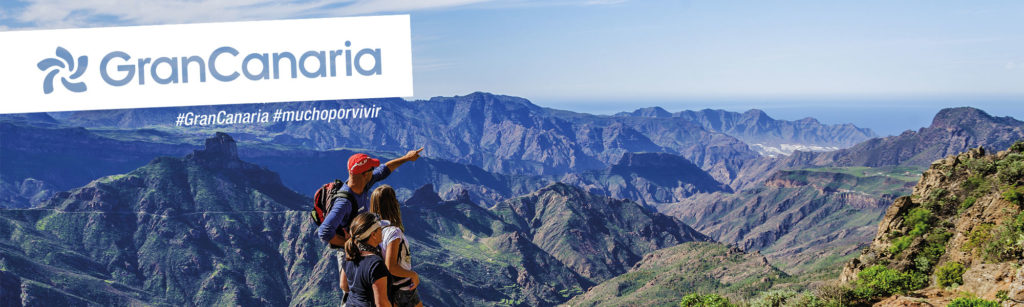
That is how we began our last journey from coast to coast, the last path through the bowels of our island. We are starting in the southeast of Gran Canaria, specifically in the Faro de Arinaga.
This lighthouse is one of the few examples of the typical and insular architecture from the end of the 19th century, which is still standing in the Canary archipelago. Designed by the Gran Canarian engineer Juan León y Castillo, the same author as the Maspalomas Lighthouse projects or the Port of La Luz and Las Palmas. Currently, it also embraces a restaurant and a terrace whose principal menu is inspired by the ocean that bathes the coast.
Again, the contrasts that this island presents are not surprising, a coast whipped by the soft and constant winds of the southeast, where undertaking a sand journey towards the Amazon jungle, exhibiting in this coast a unique image. We find a landscape very similar to our neighboring island, Fuerteventura, between rocky coast, natural pools, and long sandy beaches.
Even though this coast of our heritage presents a fairly industrialized coastline, the ocean on this side of the island remains a paradise to be discovered. A perfect place to dive among protected species such as the seahorse, the rough starfish, or the manta ray. An ocean that has allowed us to nourish a large part of the island thanks to fishing, a coast full of local establishments where you can enjoy a tasty bite of the sea.


Pozo Izquierdo
Continuing along the coast, and already entering the municipality of Santa Lucia, the landscape invites us to reflect, as we must understand that the proximity of this coast with the African continent, make both waves and winds not to have the possibility to grow in strength and size, allowing the canaries a shelter from the strong storms from the west. This coast presents a soft erosion, giving the possibility for life to develop and that is how we find the sport center of Pozo Izquierdo.
Today, many years later, Pozo Izquierdo is one of the great capitals of wind lovers. Year after year, after already 27 editions, Gran Canaria receives the caravan of the PWA World Tour. The World Windsurfing Championship in Gran Canaria is one of the major events of the professional circuit. It is also the right place for those who want to start in water wind sports, always going to one of the many specialized companies in the area, since the days of strong winds… one must have certain knowledge acquired.
Near the urban center of Pozo Izquierdo we find the ethnographic complex of the Salinas de Tenefé, which is the best preserved example of salt pans on mud in Gran Canaria. They are located on a ground of conglomerates and fluvial sands, occupying a useful surface of 20,000 meters approximately. They were built at the end of the 18th century, with the purpose of selling salt to fishing boats and for island consumption. Originally, these salt mines had three windmills that pumped water to the upper area.

Tirajana Ravine
The Tirajana ravine rises in the Caldera de Tirajana and flows into the sea through the plains of Juan Grande. This ravine covers an area of 76 square kilometers, and there we can appreciate different archaeological, botanical, and geological interests. A dam called Presa de Tirajana has been built in its basin.
In this area of the island, anyone can find numerous cheese dairies, a unique opportunity to walk among animals, and with a bit of luck, we can enjoy images to remember with herds of goats grazing in the middle of a steep bank, appreciating the skill that some animals possess when descending large slopes.
Santa Lucía and its ravine present a magical place for the eyes, a gigantic dam at the height of the Sorrueda presents a unique landscape among some of the most spectacular palm groves of Gran Canaria, the fortress of Ansite, Santa Lucía and its surrounding villages, the diversity, and friendliness of its people make this a place of dreams.

Ansite Fortress
Just before reaching the Tirajana Dam, we come across La Fortaleza, one of the most important archaeological sites of Gran Canaria, which is composed of three rocks: the Fortaleza Grande (Big Fortress), the Fortaleza Chica (Tiny Fortress) and Titana.
This place has traditionally been linked to the surrender of the aboriginal Canary Islanders to the Castilian troops on 29th April 1483, after the leader Bentejuí and the faycán of Telde fell down the cliffs with the scream of Atis Tirma. However, nowadays experts doubt that this event took place in this set. Most investigators think that this site may have been Humiaya or Humiaga, one of the great sacred spaces of the aborigines of Gran Canaria, located on the cliffs between Santa Lucía and Fataga.
This place was home to our civilization for nearly two thousand years, and today we can appreciate what life was like back then. We observe the diversity of present caves, some of which still look like a kitchen, rooms, resting places for animals, or ceremonial places, it is truly a real highlight of the island that no one should miss.
The rich archaeology of La Fortaleza (habitat, burial, storage, cultural and cave paintings) contributes to the fact that this area has been declared as a property of Cultural Interest, the highest level of protection for the cultural heritage of the Canary Islands.

Tirajana Dam and La Sorrueda
From the dam of this ravine, once we have left La Fortaleza behind, we find a spectacular view over a settlement of Canary Palm Trees, not only an oasis for the eye, but also a refuge for the locals, protected from the sun, sheltered by a gentle breeze that makes life possible on hot summer days.
The Canary Palm is and has been of vital importance to this locality. On the one hand, its leaves serve as food for goats and sheeps; on the other hand, its fruits, small dates known in the Canary Islands as támaras, are used as food for pigs, and from its trunk, traditionally and since the pre-Hispanic period, beams were obtained for the construction of roofs. The hollowed trunk was also used to build beehives to keep bees inside.
Another extremely important element for one of the aridest areas of the island has been water, which is why we find this masterpiece of hydraulic engineering. Known as the Sorrueda Dam, it was completed in 1974 and is one of the few dams in Gran Canaria built with loose materials: it is a rockfill structure with a clay core, whose maximum height from the bedrock is 74 m., with a capacity of 380,000 m3.
Undoubtedly, a view over the dam transports us to another era, brings a certain hope of recovery and development of life in the most inhospitable areas. One really has the sensation of living in another time, where life is still focused on the countryside and the silence is only interrupted by the gentle caress of the wind over the palm grove.

Ingenio de Santa Lucía
In the upper part of the ravine, above the dam, where the water flows freely in rainy weather, there are numerous attractions. Amongst the numerous hiking trails available, must be highlighted the active and present climbing community, as well as some of its picturesque villages.
All along the municipal territory of Santa Lucía, ancient paths criss-cross each other, some of them dating back to pre-Hispanic times. Five of these ancestral routes have been rescued from the old town of Santa Lucía, and have been compiled in a special publication.
- Salt Route
- Route of La Fortaleza (The Fortress)
- Route of El Ingenio
- Route of Cruz del Siglo (Cross of the Century)
- Route of the Giant’s Grave
- Route of Los Molinos (the Mills)
On the other hand, the upper area of the dam is an incredible place for the development of sports activities such as climbing. These sectors have around 70 climbing routes with an average height of 15 metres, and are suitable for all levels. It’s really an immense adventure park for the users, giving the possibility in rainy seasons of a refreshing bath in one of the countless natural pools.
Returning to the main road towards Santa Lucia de Tirajana, one kilometre before reaching the village, we pass through El Ingenio, where you can stop at the viewpoint and enjoy an unusual view, an oasis of palm and olive trees. In El Ingenio de Santa Lucia we can walk through its cobbled streets and see its centuries-old Canarian houses on both sides, where every corner could be a source of inspiration for a painter.

Montaña de los Huesos y Risco Blanco
Once we have left the middle part of the ravine, we enter the steepest part of the route, this stretch up to the summit is of high difficulty, and is also one of the most spectacular parts of the route.
We begin our ascent through the Montaña de los Huesos, the old troglodyte settlement of Tunte, between the ravines of Agualatente and La Culata, which is probably the largest group of caves on the island, and from the whole Canary Archipelago. Moreover, its elevated position and the view of the landscape it exhibits make it one of the most spectacular excursions in Gran Canaria.
It is a big settlement, a whole open village inside the rock, with more than a hundred of these rooms, connected to each other by platforms, passageways and steps also carved into the rock. Its artificial caves, hand-hewn into the rock, are arranged in four levels along the front rock. The lower levels were used as dwellings, while the higher ones were used as granaries or funerary deposits, that is why it receives the name Montaña de los Huesos (Bones Mountain).
To our right, we can see at all times the impressive natural monument of Riscos de Tirajana, located in the heart of Gran Canaria… pointing to the south. These cliffs form a great circular wall, more than ten kilometers long and almost a thousand meters high from its base, whose ends do not touch each other because the Tirajana ravine prevents them from doing so.
This superb wall delimits a large erosive depression that was formed by numerous landslides that have been reported over half a million years ago until very recently. Incrusted in this great scenery, stuck like a tooth, we find Risco Blanco, the sacred Humiaga for the ancient Canarians, a great phonolithic piton from almost four million years old which erosion has left uncovered. In this scenery of vertical walls and narrow passages, the fog may bring us the echo of the desperate footsteps of the leader Bentejuí in his flight towards the Fortress of Ansite.

Betenjuí Route
On our last stretch before reaching the summit of Gran Canaria, we found a steep ascent, with a difference in altitude of over a thousand metres in just four kilometres. This part of the path that we take uphill is the steepest part of the Betenjuí’s Route, a path that the last Canary Islanders took downhill to finish at La Fortaleza.
“My son, the Canary Islands have not yet disappeared from the world, and here you have them on these hills. Defend it to the death, because there will be no life without victory.”
With these words, a legend, a warrior, and a route were born: the Bentejuí’s Route. In the final chapters of the conquest of Gran Canaria, the last warrior, Bentejuí Semidan, along with the faycán and priest of Telde, Tazarte, made legend, a last desperate resistance that did not give in to a treaty – the Calatayud Letter – which led to the surrender and total submission of the Canary Islanders to the Crown of Castile. In this way, our warriors escaped from the exposed settlement around Roque Bentayga to hide in the steep cliffs of Tirajana, a desperate escape with a certain breadth of resistance.
And so, after a strong resistance of legs we ended up on the summit of Gran Canaria, with a look back we can observe what we had crossed in one day, a whole view from the summit to the sea through the Tirajana’s Basin.
DISCOVER THE EXPERIENCES LIVED ON DAY 1
Day 2 and 3: From Cruz de Tejeda to Agaete and Sardina Lighthouse

Caldera de Tejeda
Our second day of hiking started on the edge of the Tejeda’s caldera, we were going to cross the entire upper semicircle of what once might have been the highest mountain in the Canary Islands, a majestic volcano that one day collapsed. One really has the sensation of walking along the spine of a rock fossil, appreciating a view impossible to improve, a gift for those who enter the Caldera.
The area known as Caldera de Tejeda is a territory of volcanic origin formed by steep ravines from which two imposing crags of basaltic rock stand out: the Roque Nublo (declared as Natural Monument) which is eighty metres high (located in the geographical heart of the island, within the Rural Park of the same name) and the Roque Bentayga, a high rock outcrop in whose surroundings evidence ancient settlements that has been found in Cuevas del Rey and Roque Camello caves.
There are countless viewpoints to be found along the way, on the edge of great cliffs for the more adventurous, among pine forests for those who love the feel of our forests. The numerous trails from Cruz de Tejeda to Artenara are truly magical places to discover. There are numerous caves in which to rest on hot summer days.


Artenara
The municipality of Artenara is also located on the summit of the island of Gran Canaria, 50 kilometres from the capital and situated at 1,270 metres above sea level.
Although the municipality of Artenara is mainly inland, part of its territory reaches down to the coast, which is surrounded by the large expanses of Canary Island pine forests of the Tamadaba and Tirma areas. These places have become two of the best-preserved natural reserves in Gran Canaria.
The attractions that the village of Artenara has to offer are countless. Personally, I highly recommend visiting the interpretation center of the Risco Caído, a replica of the astronomical jewel of the ancestors of these lands, where one is impressed with the knowledge and connection they enjoyed. Also, in a more modern view, we can visit the cave house museum, to understand how the last generations have followed the tradition of living in caves.
Finally, one should not miss connecting with Artenara through its flavors and its people. That’s why we are able to visit the Bio-Tasca Arte-Gaia of our friend Juana Teresa, an opportunity to learn firsthand what Artenara is all about so that we can recharge our batteries for the road ahead. We cannot say goodbye to Artenara without visiting all its viewpoints, so we start our way to Tamadaba.

Tamadaba Natural Park
The Tamadaba Nature Park is one of the areas least altered by human hands on the island of Gran Canaria. Its 7,500 hectares stretch from summit to coast at the western end of the island, inside an area declared by Unesco as a Biosphere Reserve. We can choose between the fabulous natural forests of native Canary Island pine on the summits, the vertiginous cliffs of its almost inaccessible coastline, and the rich biodiversity of its ravines.
Tamadaba really does have a special aroma, set on immense cliffs battered by westerly storms, waves and winds that have the whole of the Atlantic to grow in strength and firmness. The intense sun evaporated that same ocean so that our pines recover that condensation, feeling the sea between pines, with a view that cuts the breath of fresh air. Tamadaba is truly a journey for the senses.
Tamadaba’s biodiversity in terms of flora, it’s full of endemic species such as the Tamadaba immortelle or the Guayedra mustard, as well as the impressive views over the cliffs, makes you feel as if you are flying over the majestic Teide in Tenerife.

San Pedro Path
We start our descent from Tamadaba towards the village of San Pedro, one does not really understand how it is possible to descend these cliffs, but there are several trails of high difficulty, and this one in San Pedro is one of the most accessible for anyone who has the habit of hiking.
We were told how the pre-Hispanic inhabitants, “when the storms failed”, would go up from the settlements in the lower areas, together with the harimaguadas, with sticks in their hands, to the Tirma mountains, where they would perform ceremonies that consisted of pouring milk and butter and singing endechas while dancing around a crag, and then going down to the sea and whipping the waters with the sticks, all this to ask for rain.
Nowadays, in June a traditional festival is still celebrated in Agaete, where the locals make this walk to the Pinar to then go down to the sea asking for water, it is really a unique opportunity to be in a local environment.
The path down to the Agaete Valley is not really long, there are some parts that need extra caution as there is a steep incline. Even so, when you look up from the path you are confronted with a breathtaking view of the entire north coast of Gran Canaria.


Agaete Valley and Las Nieves Port
We arrived tired from the long two days of walking, but as we entered the valley and felt the closeness of the sea again, we had that last breath.
Valle de Agaete (Valley) is a magical place to rest, surrounded by immense hillsides and mountains, majestic cliffs where we can see water falling, the freshness of the sea, and the humidity of Tamadaba, a paradise on Earth, where every product it offers us is a bite of heaven. I recommend a visit to a local farm, such as La Laja, to taste a variety of products.
In Puerto de las Nieves, with the sea in front of us, we felt relieved, it was almost the end, even so, it was impossible to miss the postcard that this coastline offers us. One can enjoy Tamadaba, the Cola Del Dragón, El Teide, and the power of the ocean at the same time.
Now it was time to rest, and we could not have been more grateful. We had the opportunity to spend a night in the Cordial Roca Negra in Agaete, a hotel in front of the sea, with the possibility to enjoy the sunset from the room. A terrace with incredible views of this unique environment.


North Coast and Sardina Lighthouse
On the last day of the route, we made a gentle journey along a beautiful stretch of the north coast, starting in Agaete and finding numerous bathing spots along the way. Barranco del Juncal (ravine), Playa de Lagarto (beach), Faro de Sardina (lighthouse) are some of the attractions. It is a really pleasant walk to recover after the long route.
We were very lucky to share a magical moment with Edward Fox and The Animal Kingdom, who made us vibrate with his band. It is always a great pleasure to enjoy good times with people who love this island, a trip around Gran Canaria.
DISCOVER THE EXPERIENCES LIVED ON DAY 2 AND 3
ABOUT THE PROJECT
Plan a Hike
If you are planning to come to Gran Canaria during your holidays
we can provide all that you need to have a blast on your vacation

GRAN CANARIA
PET-FRIENDLY DESTINATION
For animal lovers like us, Gran Canaria is an ideal place to travel and explore with your pet, if not, let them tell our dog Gofio how he enjoys his excursions exploring the island.
A Pet-Friendly destination par excellence, Gran Canaria is an island that loves and accepts pets. If you come on vacation to Gran Canaria you will find a variety of hotels, apartments, and rural houses that love to have animals as guests. And to eat out, don’t worry, because fortunately some restaurants and bars are pet-friendly and warmly welcome your faithful friend.
Enjoy long walks through nature and the beaches of Gran Canaria with your pets.
Check all the Pet-Friendly Gran Canaria services here:
SPONSORS AND PARTNERS